Yavapai County Sheriff’s Office:
WILDFIRE near the Village of Oak Creek on 08/13 at 3:30 pm.
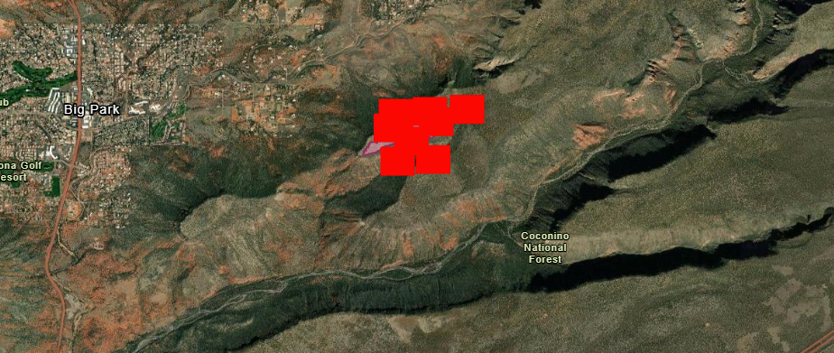
SET Status for zones YCU-1385, YCU-1388, YCU-1391, YCU-1394, YCU-1397, YCU-1400, and YCU-1403.
Residents should PREPARE NOW by gathering medications, important documents, pets and essential personal items. Consider leaving NOW if you need time to evacuate. Be ready to leave if requested.
Description
Be set to evacuate at a moment’s notice. You are in high danger in your area so follow your evacuation plan and relocate to a safe place.
From Coconino County National Forest:
The Woods Fire, located approximately 2 miles directly east of the Village of Oak Creek atop Horse Mesa is currently 55 acres and has been completely boxed in by retardant that was dropped by air resources yesterday evening.
Though the fire received moisture from monsoon storms yesterday, which aided in suppression efforts, two Hotshot crews are currently working the fire, with another crew on the way in case they are needed.
Maps of the fire area:
The Woods Fire, located approximately 2 miles directly east of the Village of Oak Creek atop Horse Mesa is currently 55 acres and has been completely boxed in by retardant that was dropped by air resources yesterday evening.
Though the fire received moisture from monsoon storms yesterday, which aided in suppression efforts, two Hotshot crews are currently working the fire, with another crew on the way in case they are needed.
You can also see info on this map by zooming in just East of Big Park near the Village of Oak Creek:
WildFire Map


